





GPS Tracking Study Reveals Remarkable Flexibility in European Honey Buzzard Migration Routes, with Libya Within the Wider Migration Region
In 2026, the Journal of Ornithology published a scientific study entitled “Remarkable plasticity in route choice by migrating European Honey Buzzards from north-eastern Poland.”
The study investigated the migration routes of the European Honey Buzzard (Pernis apivorus) and examined how consistently individuals followed the same routes from year to year, using Global Positioning System (GPS) tracking devices.
Researchers tracked five adult males breeding in northeastern Poland between 2018 and 2024 to investigate their movements between European breeding grounds and African wintering areas.
Four major migration routes
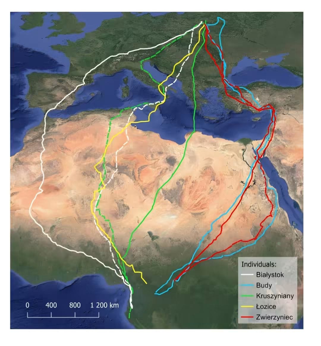
The study revealed remarkable flexibility in migration route selection. Although the birds’ breeding sites were separated by no more than approximately 60 km, individuals followed four distinct major routes via:
🔹 The Strait of Gibraltar
🔹 The Italian Peninsula
🔹 The Balkan Peninsula
🔹 The Bosporus Strait
The maximum separation between these routes reached approximately 3,750 km. However, the routes converged towards the wintering areas in Africa, where the maximum separation between them did not exceed approximately 575 km.
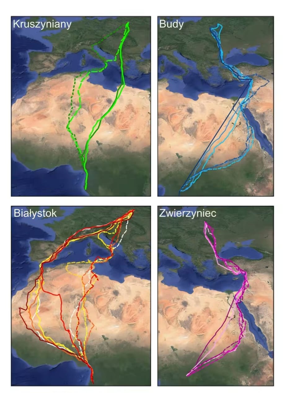
The birds also demonstrated an ability to change their migration routes between years, potentially avoiding geographical barriers such as mountains, seas, and deserts.
Migration distances and seasonal movements
The tracking maps published in the study illustrate the European Honey Buzzard’s migration routes from Europe through North Africa towards wintering areas south of the Sahara.
The actual distances travelled varied considerably between individuals and seasons:
- Autumn migration: approximately 6,470–9,253 km.
- Spring migration: approximately 7,178–8,215 km.
The study also found greater variation in the dates on which birds arrived at their breeding grounds than in the dates on which they departed for their African wintering areas. This suggests that environmental conditions encountered during migration, particularly when crossing the Sahara Desert, may influence the timing of their journeys.
What do these findings mean for Libya?
The tracking maps highlight the broader network of migration routes connecting Europe, North Africa, and sub-Saharan Africa. Libya’s geographical position makes the country relevant to understanding the movements of migratory raptors travelling between the two continents.
Investigating routes that cross Libyan territory, alongside monitoring birds at stopover and passage sites, can help improve our understanding of the seasonal movements of this species and other migratory birds of prey.
The study demonstrates that individuals of the same species, including birds breeding relatively close to one another, may follow remarkably different migration routes. It also highlights the value of GPS tracking and satellite telemetry in revealing movement patterns that would be difficult to understand through field observations alone.
These findings reinforce the importance of continued bird monitoring in Libya and international cooperation to better understand and conserve migratory raptors across their European and African ranges.
📸 Bird photograph: Khaled Al-Ratab
🗺️ Tracking maps: Mirski et al. (2026), Journal of Ornithology.
Leave a Reply